Regional overview
Iceland’s interior and glacier-margin hiking areas combine rhyolite mountains, basalt lava fields, geothermal valleys, ash deserts, crater rows, ice-cap views and exposed high passes. The main walking centres for this selection are Landmannalaugar, Kerlingarfjöll, Askja, Þórsmörk–Skógar and Skaftafell / Vatnajökull National Park.
Access is a major part of the hiking character. Several starts are reached by highland F-roads or seasonal mountain buses, and conditions can change quickly. Icelandic weather and road conditions can differ sharply from expectations and change fast. Mountain-road access should be checked before planning highland routes.
The practical hiking season is usually summer to early autumn, but this varies by road, snow cover and weather. High passes such as Fimmvörðuháls can hold snow into summer. Geothermal terrain may have fragile crusts and boiling springs, and white-out navigation can become serious on lava, ash, snowfields and glacier-edge terrain.
Selection rationale
These five hikes were chosen to represent the region’s defining walking experiences: rhyolite highlands at Landmannalaugar, active geothermal mountains at Kerlingarfjöll, a remote volcanic caldera at Askja, a classic high pass between glaciers on Fimmvörðuháls, and a glacier-edge alpine circuit at Skaftafell.
The list balances iconic routes, volcanic landforms, glacier views and feasible day-hike variants.
Summary table
| # | Hike | Country | Route type | Distance | Gain | Max elevation | Difficulty |
|---|---|---|---|---|---|---|---|
| 1 | Bláhnúkur and Brennisteinsalda Loop, Landmannalaugar | Iceland | Loop | 9.7–11 km | ~600–620 m | 945 m | Moderate–hard |
| 2 | Hveradalahringur, Kerlingarfjöll | Iceland | Loop | 4 km | ~100 m | Not verified | Moderate; short but rough |
| 3 | Askja: Vikraborgir to Víti and Öskjuvatn | Iceland | Out-and-back | ~5 km | ~230 m | ~1,053 m lake level; max unresolved | Easy–moderate |
| 4 | Fimmvörðuháls: Skógar to Þórsmörk | Iceland | Point-to-point | 25 km | 1,000–1,220 m | ~1,000–1,040 m | Very strenuous |
| 5 | Kristínartindar Circuit, Skaftafell | Iceland | Loop | 17.9–18.4 km | 1,050–1,215 m | ~1,126 m | Difficult |
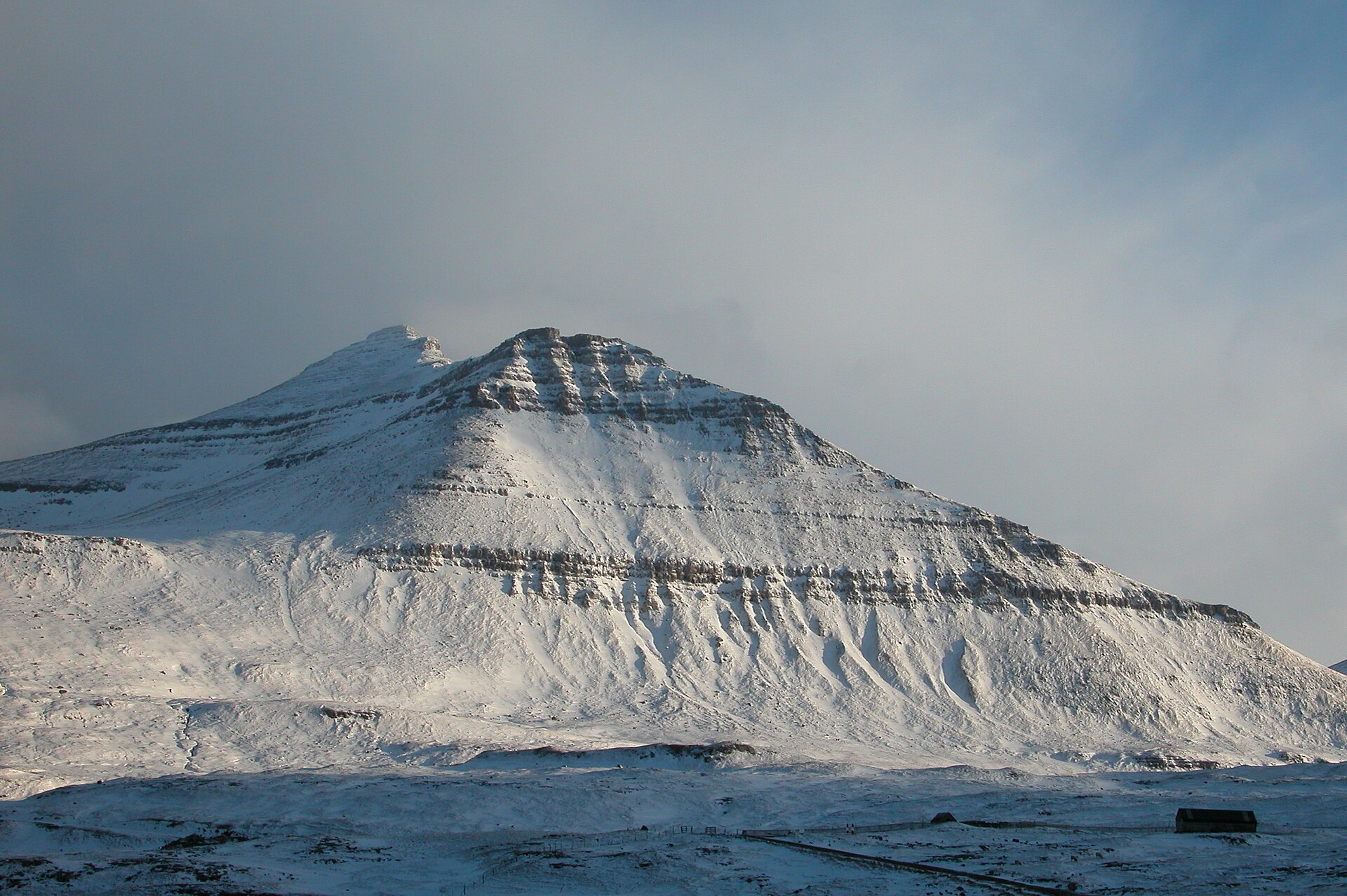
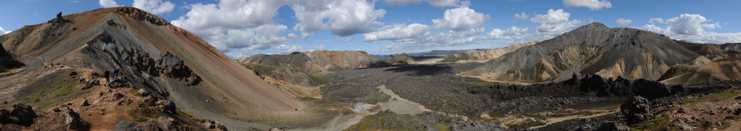
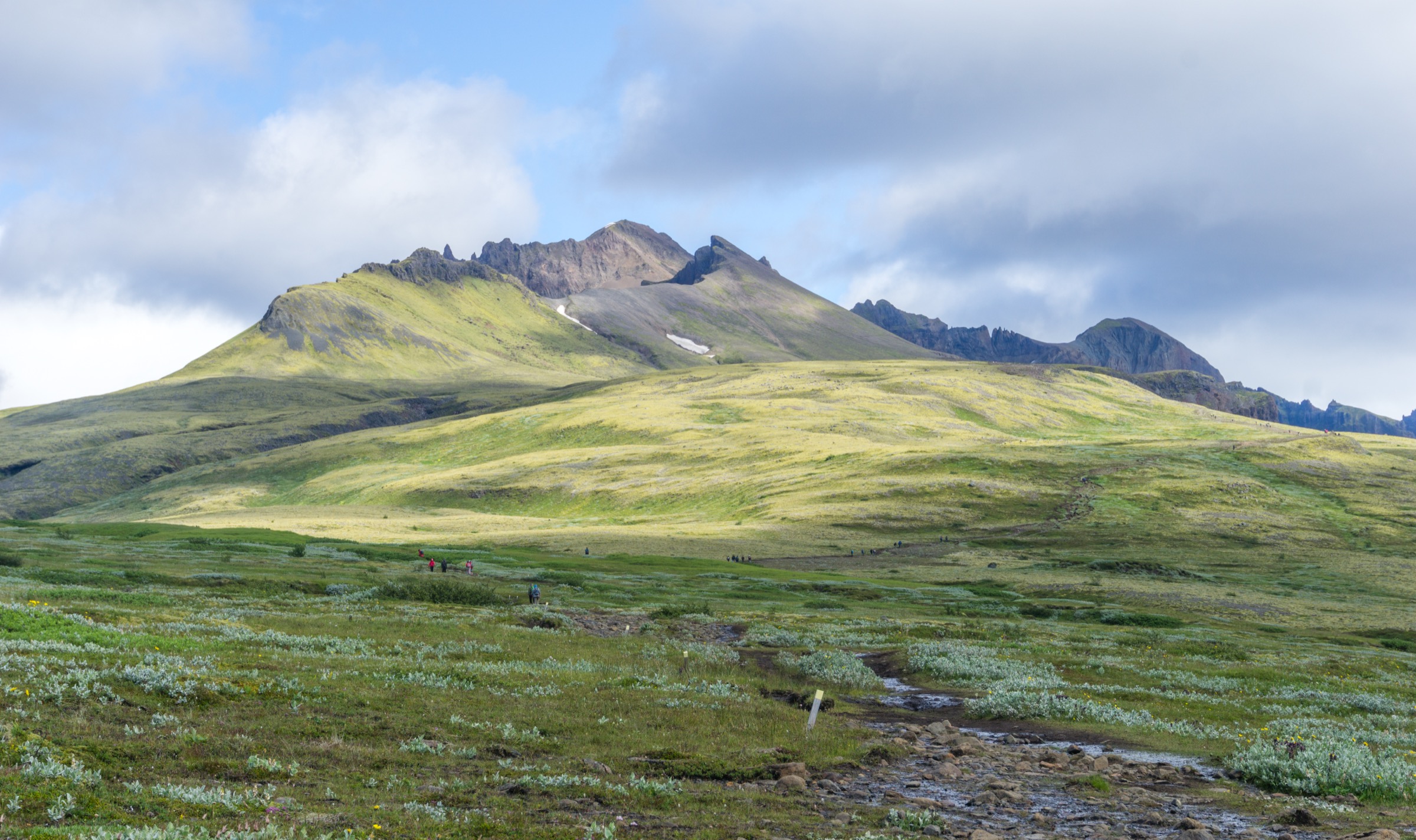
1. Bláhnúkur and Brennisteinsalda Loop, Landmannalaugar
Snapshot
Itinerary
The route starts near the Landmannalaugar hut and crosses the Brennisteinsöldukvísl before climbing the dark slopes of Bláhnúkur. The trail reaches the 945 m summit, then descends towards Grænagil. The fuller day-hike variant continues towards Brennisteinsalda before returning through the Laugahraun lava field and geothermal terrain to Landmannalaugar.
Why it is essential
This is the classic Landmannalaugar day-hike combination: black volcanic slopes, rhyolite ridges, geothermal colours, lava-field walking and wide views over the Fjallabak interior.
Equipment
- Sturdy boots
- Waterproof and windproof layers
- Warm layer
- Hat and gloves outside stable midsummer weather
- Food and water
- Map/GPS
- Navigation backup
- Trekking poles recommended
- Microspikes may be useful if snow remains early in the season
Hazards and notes
- Remote highland setting
- Fast-changing weather
- Snow patches possible early in the season
- Poor visibility can make navigation difficult
- Slippery volcanic gravel on upper slopes
- Access depends on seasonal highland roads and buses
- Remain on marked paths in geothermal areas
GPX / KML links
| Source | URL | Format | Notes |
|---|---|---|---|
| Iceland Touring Association — Bláhnúkur route page | fi.is | Official route page / map source | No downloadable GPX licence found; use as official verification source; not a direct reusable GPX |
| HorizonRando — Bláhnúkur and Brennisteinsalda | horizonrando.fr | Route page with GPX/source route indicated | Terms not fully verified; route-file source located; replace later with custom version |
| Wikiloc — Landmannalaugar Brennisteinsalda Bláhnúkur | wikiloc.com | GPS route page | Wikiloc terms unresolved; route-source link included for later replacement |
Sources
- Iceland Touring Association — Bláhnúkur
- Landmannalaugar hiking routes
- Environment Agency of Iceland — Fjallabak Nature Reserve
- HorizonRando — Bláhnúkur and Brennisteinsalda
- Wikiloc — Landmannalaugar Brennisteinsalda Bláhnúkur
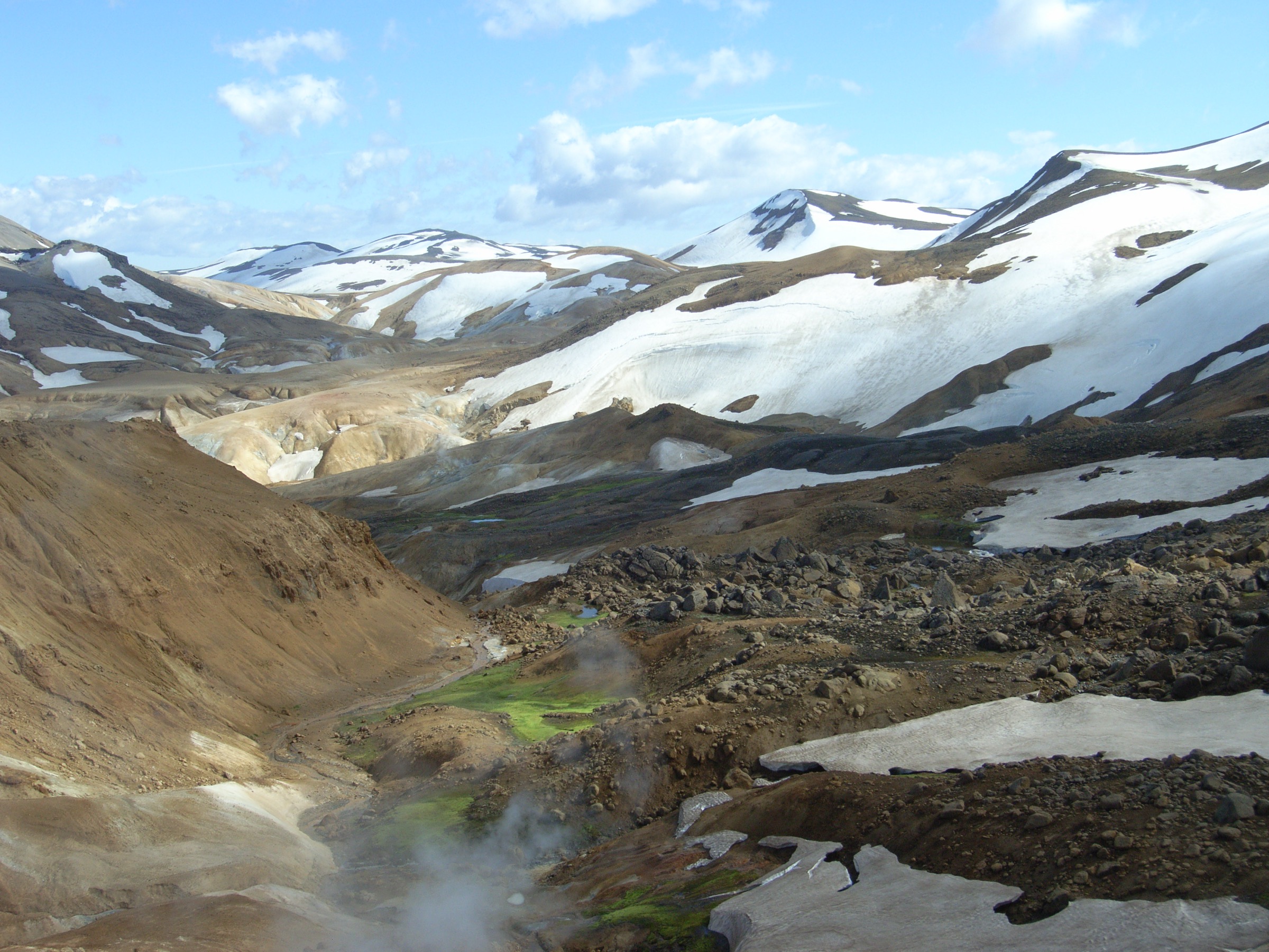
2. Hveradalahringur, Kerlingarfjöll
Snapshot
Itinerary
The Hveradalahringur is a short circuit through the lower Hveradalir geothermal area in Kerlingarfjöll. The route starts from the Neðri-Hveradalir parking area and follows marked paths through steaming valleys, hot springs, colourful slopes and eroded geothermal terrain. The official protected-area trail PDF gives the Hveradalir Circle as a 4 km circular route with around 100 m of ascent and a walking time of 1–2 hours.
Why it is essential
Kerlingarfjöll is one of the central Highlands’ defining geothermal mountain areas. This short route gives direct access to the core landscape: steaming valleys, mineral-coloured slopes and fragile volcanic-geothermal terrain.
Equipment
- Hiking boots with good grip
- Waterproof shell
- Warm layer
- Water
- Food
- Map/GPS
- Sun protection
- Trekking poles useful on loose or slippery paths
Hazards and notes
- Remain on marked paths
- Hidden or newly opened geothermal activity is possible
- Boiling springs and fragile geothermal crusts
- Slippery steps and paths
- Unreliable mobile coverage
- Fast-changing central Highland weather
GPX / KML links
| Source | URL | Format | Notes |
|---|---|---|---|
| Official Kerlingarfjöll trail PDF | co2.ust.is | PDF map / route description | No GPX licence found; official route verification; not a direct reusable GPX |
| Highland Base — Hveradalir guided hike | highlandbase.is | Route/stat page | Commercial site terms not verified; secondary verification only |
| Wikiloc — Kerlingarfjöll Hveradalir | wikiloc.com | GPS route page | Wikiloc terms unresolved; route-source link included for later replacement |
Sources
- Official Kerlingarfjöll trail map PDF
- Highland Base — Hveradalir guided hike
- Wikiloc — Kerlingarfjöll Hveradalir
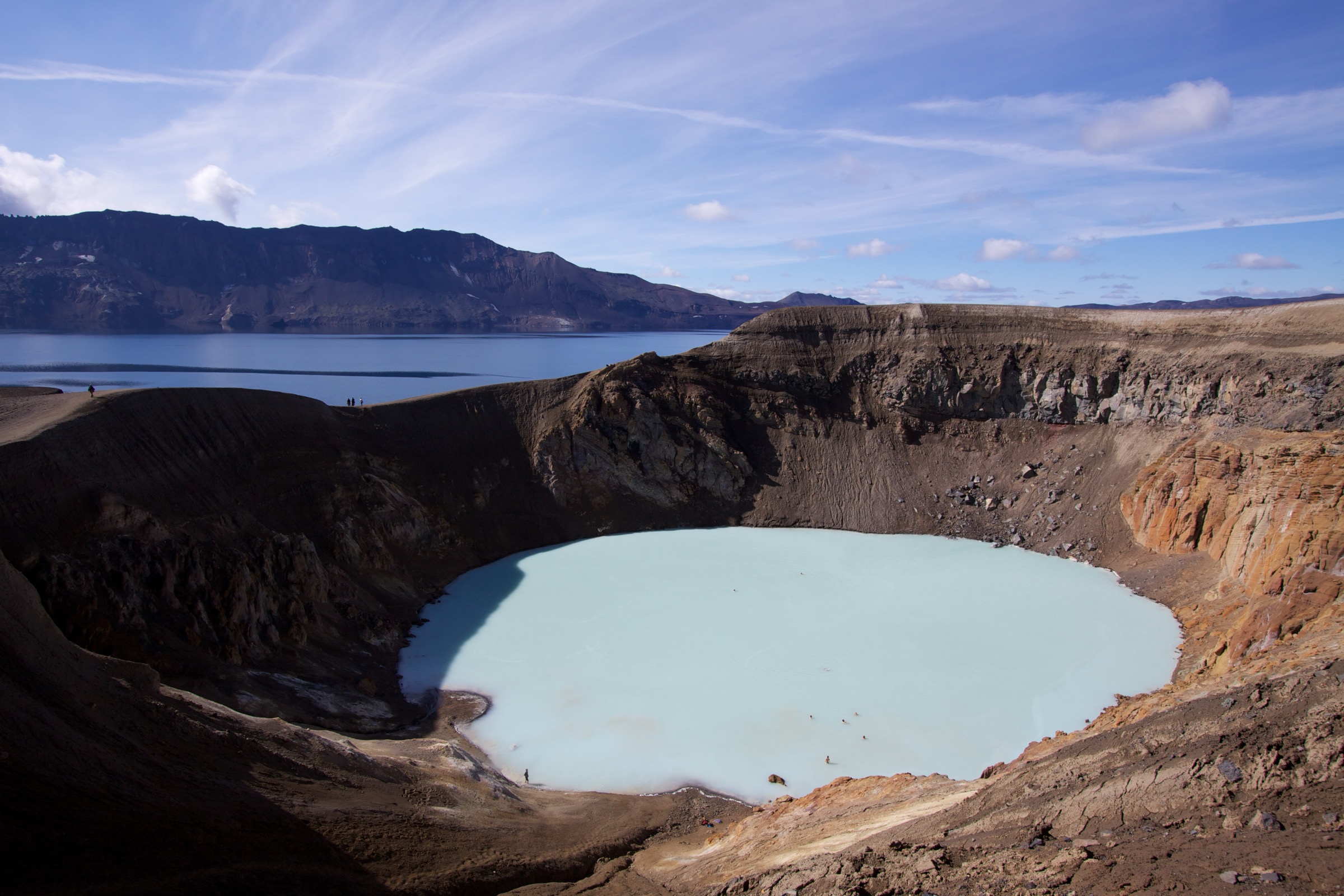
3. Askja: Vikraborgir to Víti and Öskjuvatn
Snapshot
Itinerary
The route begins at Vikraborgir and follows the marked trail across the Askja caldera area towards Víti and Öskjuvatn. Vatnajökull National Park lists the Vikraborgir–Öskjuvatn trail as 2.5 km, about 2 hours and easy. Most walkers treat this as an out-and-back day walk from the car park, with a return distance around 4.5–5 km depending on the exact line and crater-rim variant.
Why it is essential
Askja is one of Iceland’s great remote volcanic landscapes: a high caldera, the pale crater lake of Víti and the large lake Öskjuvatn. The hike is short, but the setting is exceptionally high-value and highly representative of the barren central Highlands.
Equipment
- Sturdy walking shoes or boots
- Windproof and waterproof layers
- Warm layer
- Water
- Food
- Map/GPS
- Navigation backup
- Extra clothing for remote highland conditions
Hazards and notes
- Short but remote route
- Access is by highland roads that may be closed or difficult
- Snow patches possible early in summer
- Descent into Víti can be slippery
- Rock or mud slides are possible
- Do not descend to the crater lake unless local conditions are clearly safe
GPX / KML links
| Source | URL | Format | Notes |
|---|---|---|---|
| Vatnajökull National Park — Askja trail page | vatnajokulsthjodgardur.is | Official route description / map source | No GPX licence found; official verification; not a direct reusable GPX |
| Wikiloc — Askja lake and Víti | wikiloc.com | GPS route page | Wikiloc terms unresolved; route-source link included for later replacement |
| Etnatracking — Askja Víti crater | etnatracking.com | GPX/KML source page, login may be required | Terms not verified; source located; direct file not verified |
Sources
- Vatnajökull National Park — Askja
- Iceland Dream — Askja
- Wikiloc — Askja lake and Víti
- Etnatracking — Askja Víti crater
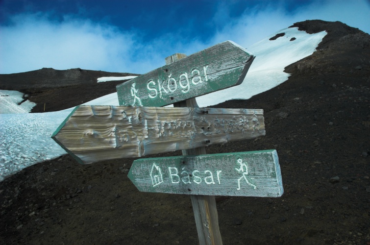
4. Fimmvörðuháls: Skógar to Þórsmörk
Snapshot
Itinerary
The trail links Skógar and Þórsmörk across the Fimmvörðuháls pass between Eyjafjallajökull and Mýrdalsjökull. From Skógar, the first section follows the Skógá river past a long sequence of waterfalls to the bridge and on towards Baldvinsskáli. The second section crosses the high pass, passes the Goðahraun lava and Magni and Móði craters, then descends through steep and sometimes snowy ground, including Brattafönn, Heljarkambur and Kattarhryggir, before reaching Þórsmörk.
Why it is essential
Fimmvörðuháls is one of Iceland’s most famous one-day mountain traverses for very fit hikers. It combines waterfalls, volcanic eruption history, new lava, glacier-adjacent high ground and the dramatic descent into Þórsmörk.
Equipment
- Sturdy waterproof boots
- Waterproof and windproof shell
- Warm insulating layer
- Hat and gloves
- Food and water
- Navigation backup
- Headtorch
- Emergency layer
- Trekking poles
- Microspikes may be useful if snow remains
Hazards and notes
- Serious long day despite marked trail
- Snow can remain well into summer
- Fog, strong winds and sudden storms are possible
- Steep snowy ground at Brattafönn
- Narrow ridge with chains at Heljarkambur
- Navigation can be difficult in poor visibility
- Generally recommended from Skógar towards Þórsmörk
- Average opening is late June to mid-September
GPX / KML links
| Source | URL | Format | Notes |
|---|---|---|---|
| Iceland Touring Association — Fimmvörðuháls trail page | fi.is | Official route description / map source | No direct GPX licence found; official verification; not a direct reusable GPX |
| Wikiloc — Fimmvörðuháls Skógar–Þórsmörk | wikiloc.com | GPS route page | Wikiloc terms unresolved; route-source link included for later replacement |
| HorizonRando — Fimmvörðuháls | horizonrando.fr | Route/source page | Site terms not fully verified; secondary route-file source; replace later with custom version |
Sources
- Iceland Touring Association — Fimmvörðuháls
- Wikiloc — Fimmvörðuháls Skógar–Þórsmörk
- HorizonRando — Fimmvörðuháls
5. Kristínartindar Circuit, Skaftafell
Snapshot
Itinerary
The Kristínartindar circuit starts at Skaftafell Visitor Centre and climbs through the Skaftafellsheiði trail network towards the Kristínartindar summit ridge. The official S4 route is a 17.9 km circular hike taking 6–8 hours, with 1,215 m of elevation. In good visibility it gives views towards the Öræfi mountains, southern Vatnajökull and Skeiðarársandur.
Why it is essential
Kristínartindar is the strongest glacier-edge mountain day in this selection. It gives high views over Skaftafellsjökull, Morsárjökull, the Vatnajökull margin and the outwash plains, making it a natural complement to the volcanic highland routes.
Equipment
- Sturdy boots
- Waterproof and windproof layers
- Warm layer
- Food
- Water
- Map/GPS
- Navigation backup
- Trekking poles
- Headtorch for late finishes
- Microspikes may be useful if snow or ice remains on the upper route
Hazards and notes
- Difficult mountain circuit
- Loose rock
- Steep ground
- Exposed-feeling upper sections
- Avoid in poor visibility, strong wind, ice or lingering snow unless suitably experienced and equipped
- Water availability may be limited on the higher circuit
GPX / KML links
| Source | URL | Format | Notes |
|---|---|---|---|
| Vatnajökull National Park — S4 Kristínartindar | vatnajokulsthjodgardur.is | Official route description / map source | No direct GPX licence found; official verification; not a direct reusable GPX |
| Wikiloc — Kristínartindar trail | fr.wikiloc.com | GPS route page | Wikiloc terms unresolved; route-source link included for later replacement |
| HorizonRando — Kristínartindar | horizonrando.fr | Route/source page | Site terms not fully verified; secondary route-file/stat source; replace later with custom version |
Sources
- Vatnajökull National Park — Kristínartindar S4
- Wikiloc — Kristínartindar
- HorizonRando — Kristínartindar
- Summit Cairn — Kristínartindar
Region-level sources
| Source | Use | URL |
|---|---|---|
| Iceland Touring Association — Bláhnúkur | Landmannalaugar official route | fi.is |
| Iceland Touring Association — Fimmvörðuháls | Fimmvörðuháls official route | fi.is |
| Vatnajökull National Park — Askja | Askja official route | vatnajokulsthjodgardur.is |
| Vatnajökull National Park — Kristínartindar S4 | Kristínartindar official route | vatnajokulsthjodgardur.is |
| Official Kerlingarfjöll trail map PDF | Kerlingarfjöll official map | co2.ust.is |
| SafeTravel Iceland | Travel safety guidance | safetravel.is |
| Vegagerðin road conditions | Road conditions | road.is |
| Landmannalaugar hiking routes | Landmannalaugar route hub | landmannalaugar.org |
| HorizonRando — Bláhnúkur and Brennisteinsalda | Landmannalaugar route source | horizonrando.fr |
| HorizonRando — Fimmvörðuháls | Fimmvörðuháls route source | horizonrando.fr |
| HorizonRando — Kristínartindar | Kristínartindar route source | horizonrando.fr |
| Wikiloc — Landmannalaugar Brennisteinsalda Bláhnúkur | Landmannalaugar GPS source | wikiloc.com |
| Wikiloc — Kerlingarfjöll Hveradalir | Kerlingarfjöll GPS source | wikiloc.com |
| Wikiloc — Askja lake and Víti | Askja GPS source | wikiloc.com |
| Wikiloc — Fimmvörðuháls Skógar–Þórsmörk | Fimmvörðuháls GPS source | wikiloc.com |
| Wikiloc — Kristínartindar | Kristínartindar GPS source | fr.wikiloc.com |
| Etnatracking — Askja Víti crater | Askja route-file source | etnatracking.com |