Regional overview
The Faroe Islands are a North Atlantic walking region of steep grass mountains, basalt cliffs, sea stacks, high village paths, exposed headlands and treeless uplands. Most hikes are not high by Alpine standards, but many start near sea level and climb quickly into open, weather-sensitive terrain. Slættaratindur, the highest summit, rises to 880 m and gives views across the archipelago in clear weather.
The main hiking bases are Tórshavn for Streymoy, Vágar and Eysturoy; Klaksvík for the northern islands, including Kalsoy; and Tvøroyri for Suðuroy. Access can involve ferries, buses, one-lane roads, small car parks and private-land trailheads. Some high-profile walks now have local access fees or mandatory check-in points, especially Trælanípan and Kallur.
Typical best season is late spring to early autumn, when daylight is long and snow or ice is less likely. Even in summer, fog, wind and wet grass can make simple routes serious. Official safety guidance for the Faroes stresses staying on paths and cairns, dressing for fast-changing weather, preparing before departure, and watching for marshland and cliff danger.
Selection rationale
These five hikes give a balanced Faroe Islands set: the national high point, the lake-above-the-ocean coastal viewpoint, the classic Kallur Lighthouse headland, the historic Saksun–Tjørnuvík village path, and the Suðuroy valley-and-lake walk at Hvannhagi. Mykines and Cape Enniberg were not selected because current access, guiding or closure issues make them less straightforward as general catalogue day-hikes.
Summary table
| # | Hike | Route type | Distance | Gain | Max elevation | Difficulty |
|---|---|---|---|---|---|---|
| 1 | Slættaratindur from Eiðisskarð | Out-and-back | 3.3–5.6 km | 475–493 m | 880 m | Moderate mountain hike |
| 2 | Trælanípan, Sørvágsvatn / Leitisvatn and Bøsdalafossur | Out-and-back | 7 km | ca. 83 m | ca. 92 m route; 142 m cliff | Easy–Moderate |
| 3 | Kallur Lighthouse from Trøllanes | Out-and-back | ca. 4.8 km | ca. 327 m | ca. 197 m | Easy–Moderate, but exposed |
| 4 | Saksun–Tjørnuvík village path | Point-to-point | 7 km | 529 m | 522 m | Medium |
| 5 | Hvannhagi and Hvannavatn from Tvøroyri | Return route | 6 km | 371 m | 230 m | Medium |
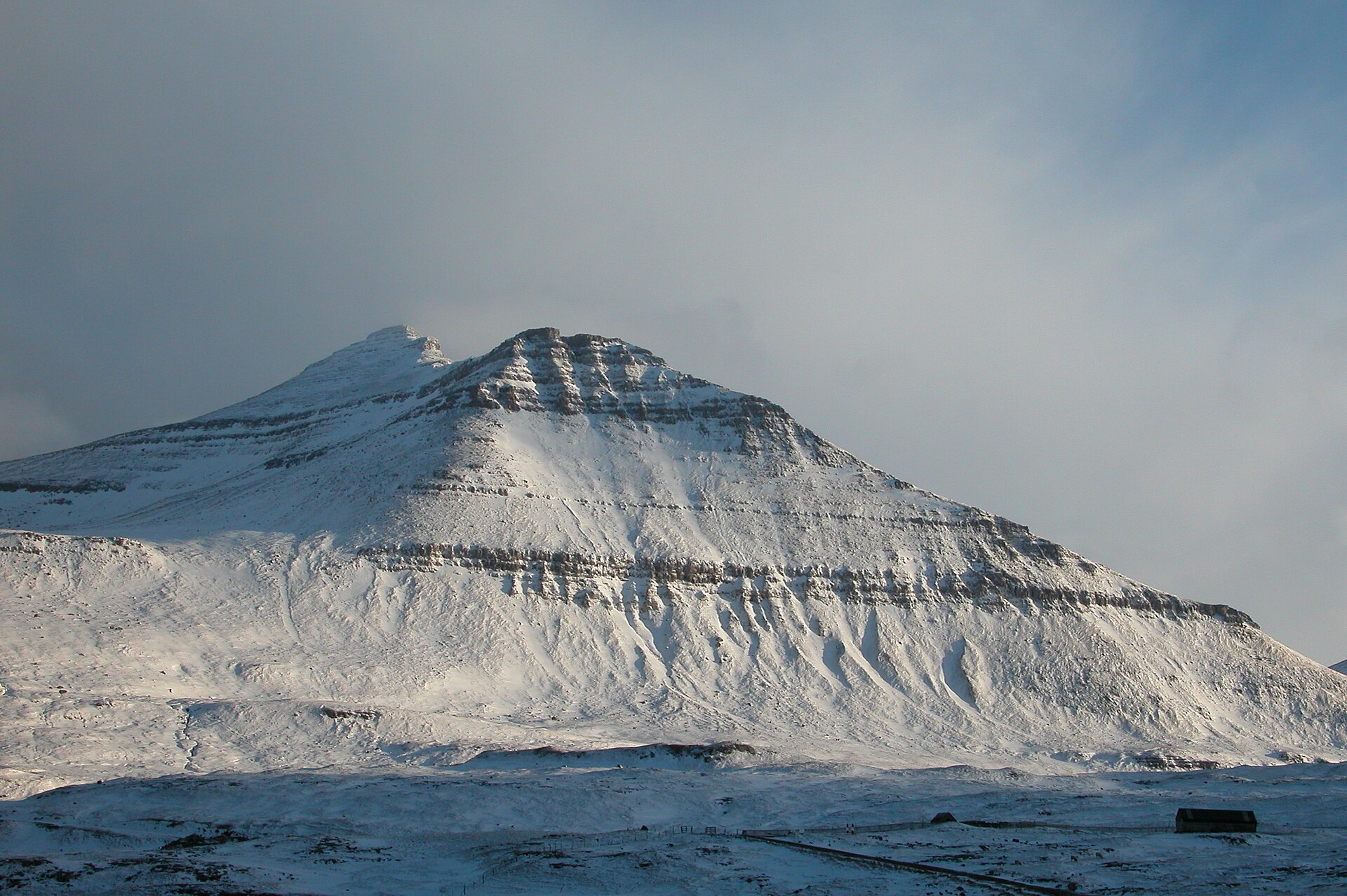
1. Slættaratindur from Eiðisskarð
Snapshot
Itinerary
The route starts at the high road pass between Eiði and Funningur. From the small parking area, the line climbs directly over grassy slopes towards Slættaratindur. The upper part steepens and becomes rockier before reaching the broad, flat summit plateau. Descent is by the same general line to Eiðisskarð. Outdooractive records a 3.3 km version with 475 m ascent and 471 m descent; other GPS traces record a longer 5.4 km loop-like variant, so distance should be treated as route-dependent.
Why it is essential
Slættaratindur is the highest mountain in the Faroe Islands at 880 m. It is the natural high-point hike for the archipelago and, in clear conditions, gives broad views over the islands.
Equipment
- Sturdy waterproof boots
- Waterproof and windproof layer
- Warm layer
- Hat and gloves outside settled midsummer weather
- Food and water
- Map/GPS
- Navigation backup
- Trekking poles recommended
Hazards and notes
- Wet grass can be slippery on descent.
- The summit is exposed to sudden fog and wind.
- Visibility can deteriorate quickly.
- Winter solo attempts are not recommended because snow can hide the path and icy surfaces can occur from November to April.
GPX / KML links
| Source | URL | Format | Notes |
|---|---|---|---|
| Outdooractive community route | outdooractive.com | Source map / route page | Useful for verification; direct reuse unresolved |
| Wikiloc Slættaratindur trace | wikiloc.com | GPX source page | Download/source route found; reuse unresolved |
| Official Visit Faroe Islands place page | visitfaroeislands.com | Official place source, not GPX | No official GPX found |
Sources
- Visit Faroe Islands — Slættaratindur
- Outdooractive — Slættaratindur mountain hike
- Wikiloc — Slættaratindur
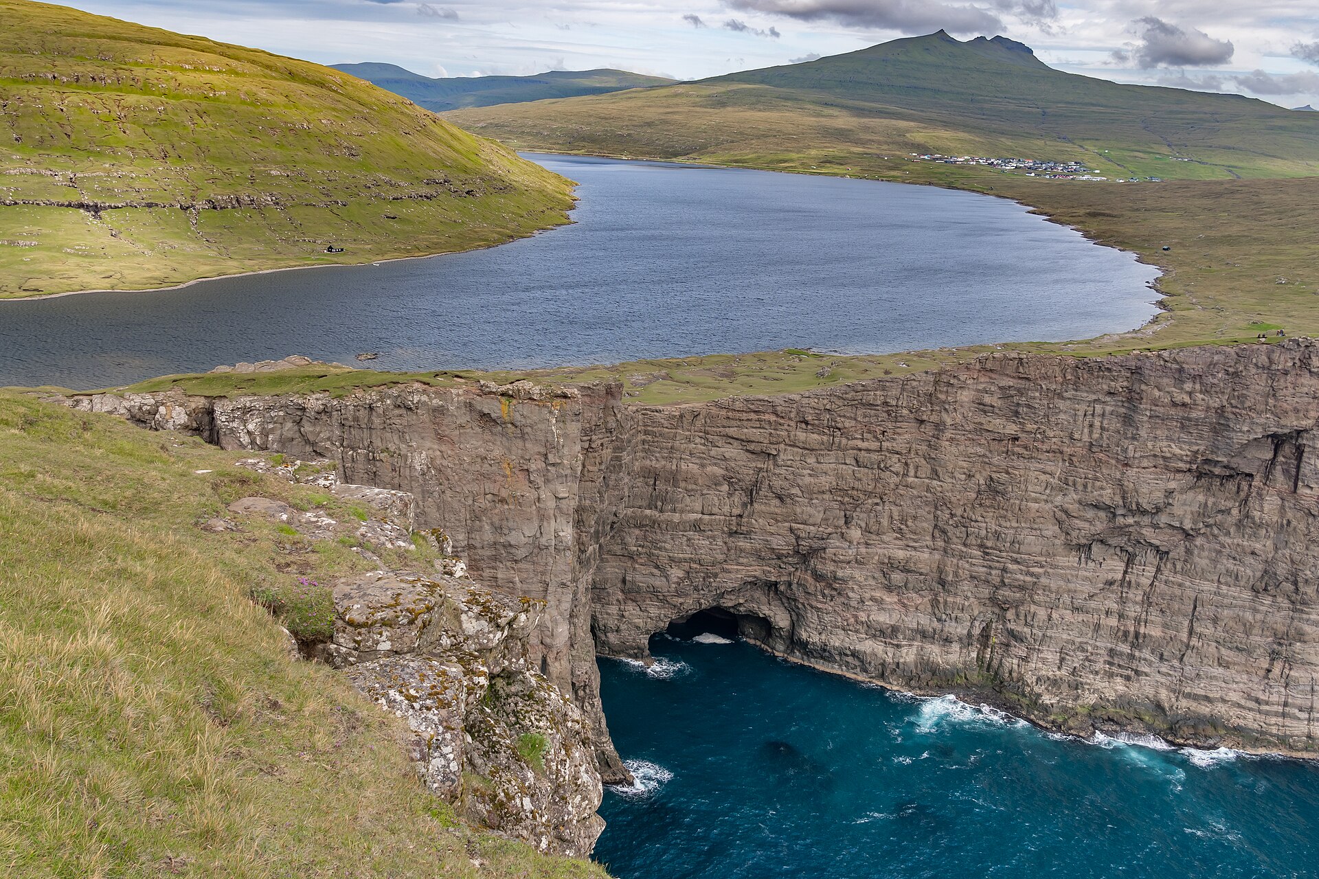
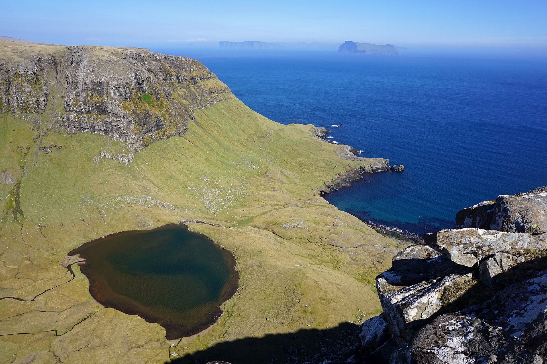
2. Trælanípan, Sørvágsvatn / Leitisvatn and Bøsdalafossur
Snapshot
Itinerary
The marked route leaves the reception area and follows the designated trail above Lake Leitisvatn/Sørvágsvatn. It continues towards the Trælanípan viewpoints, where the lake appears to hang above the Atlantic from a particular angle, then continues towards views of Bøsdalafossur, where the lake drains into the sea. The current visitor information states that the path along Lake Leitisvatn itself is closed for bird protection and that the designated route should be followed.
Why it is essential
This is the Faroes’ most recognisable low-level coastal walk: it combines the optical-illusion lake view, the 142 m Trælanípa sea cliff and the 30 m Bøsdalafossur waterfall.
Equipment
- Hiking shoes or boots
- Waterproof layer
- Warm layer
- Water
- Food
- Map/GPS
- Sun protection
- Waterproof footwear recommended after rain
Hazards and notes
- Access fee currently applies.
- Cliff edges are exposed.
- The lake-shore path closure for bird protection should be respected.
- Strong wind and poor visibility can make the viewpoint area unsafe.
GPX / KML links
| Source | URL | Format | Notes |
|---|---|---|---|
| Visorando route | visorando.com | GPX download and PDF source page | Source route found; direct reuse unresolved |
| Trælanípan official visitor site | tralanipan.fo | Official route information and map images | Official stats verified; no official GPX found |
Sources
- Trælanípan official site
- Trælanípan — Information and guidance
- Visorando — Sørvágsvatn, Trælanípa et Bøsdalafossur
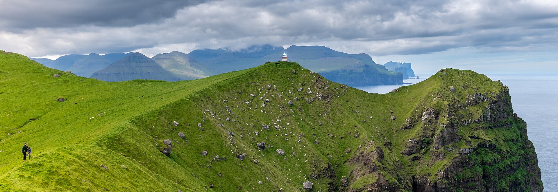
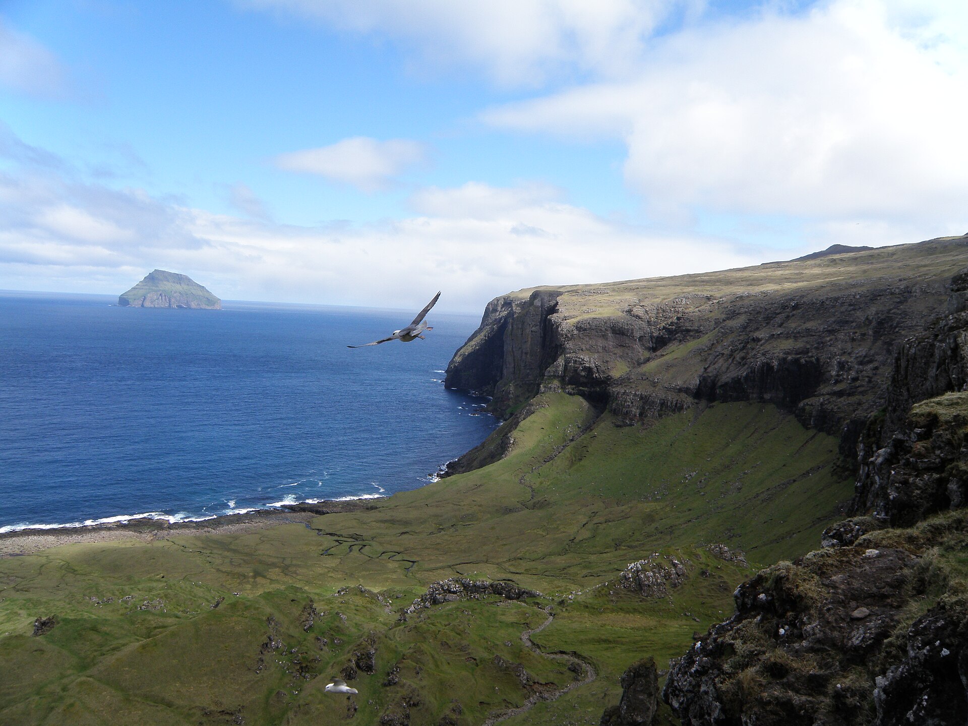
3. Kallur Lighthouse from Trøllanes
Snapshot
Itinerary
From Trøllanes, the path climbs over open grassland towards the northern headland of Kalsoy and the small Kallur Lighthouse. The usual route returns by the same line. The optional continuation to the classic lighthouse viewpoint is more exposed and should only be considered in calm, dry conditions. Moonhoney gives 4.8 km out-and-back, 1 h 45 min, 327 m gain/loss and 197 m maximum elevation; Hiking.fo lists the official access product as a moderate 2–5 km hike.
Why it is essential
Kallur is one of the defining Faroese coastal walks: a short but memorable headland route combining sheep pasture, high Atlantic cliffs, lighthouse views and the long, narrow shape of Kalsoy. It also represents the northern-island walking character better than a longer technical summit route.
Equipment
- Sturdy waterproof boots
- Waterproof and windproof layers
- Warm layer
- Food
- Water
- Map/GPS
- Ferry and bus timetable backup
- Trekking poles useful on muddy grass
Hazards and notes
- Access fee currently applies.
- The lighthouse viewpoint involves steep cliffs and wind exposure.
- Ferry capacity to Kalsoy is limited.
- Bus 506 is linked to the ferry timetable, so current SSL schedules should be checked before departure.
GPX / KML links
| Source | URL | Format | Notes |
|---|---|---|---|
| Roadtripster Kallur route | roadtripster.net | GPX source page | GPX availability verified; reuse unresolved |
| Roadtripster direct GPX | roadtripster.net | GPX | Direct GPX located; reuse unresolved |
| Komoot smart route | komoot.com | GPX after login | Useful as secondary route source; reuse unresolved |
| Topo GPS Trøllanes to Kallur Lighthouse | topo-gps.com | GPX download | Source route found; statistics differ from Moonhoney |
Sources
- Hiking.fo — Kallur Lighthouse hiking fee
- Moonhoney Travel — Kallur Lighthouse, Kalsoy
- Roadtripster — Kallur Lighthouse, Kalsoy
- Roadtripster direct Kallur GPX
- Komoot — Kallur smart tour
- Topo GPS — Trøllanes to Kallur Lighthouse
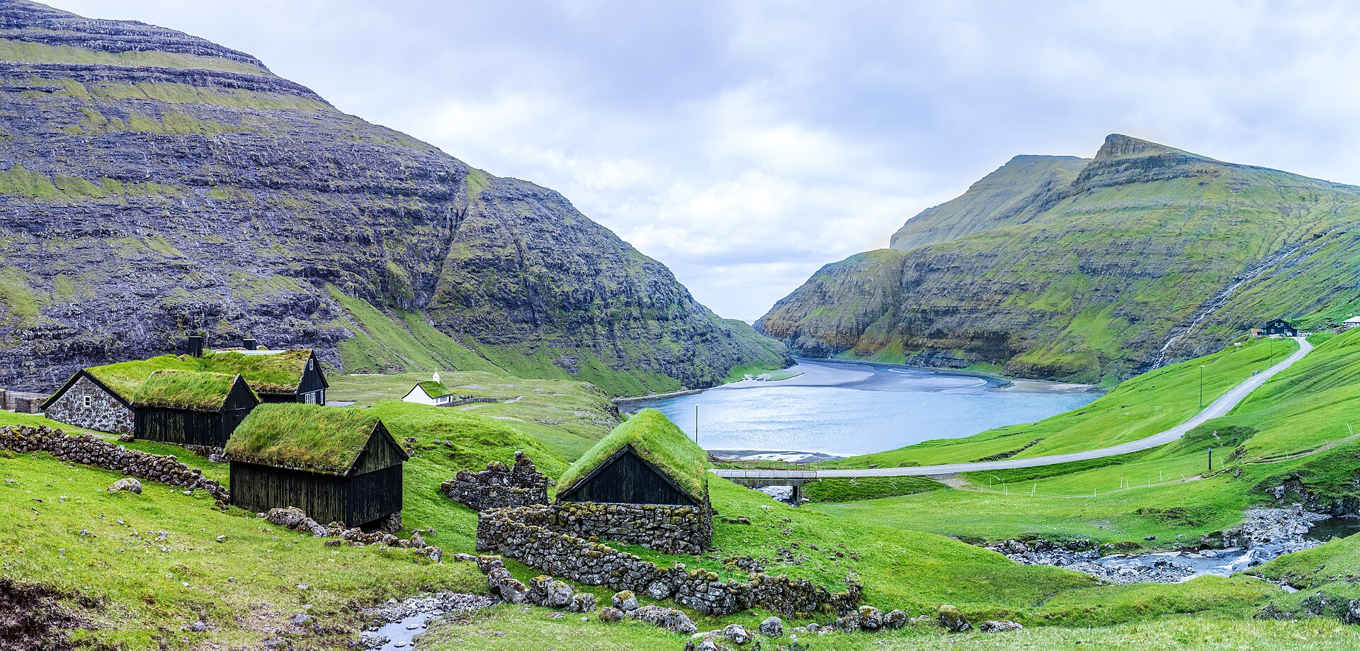
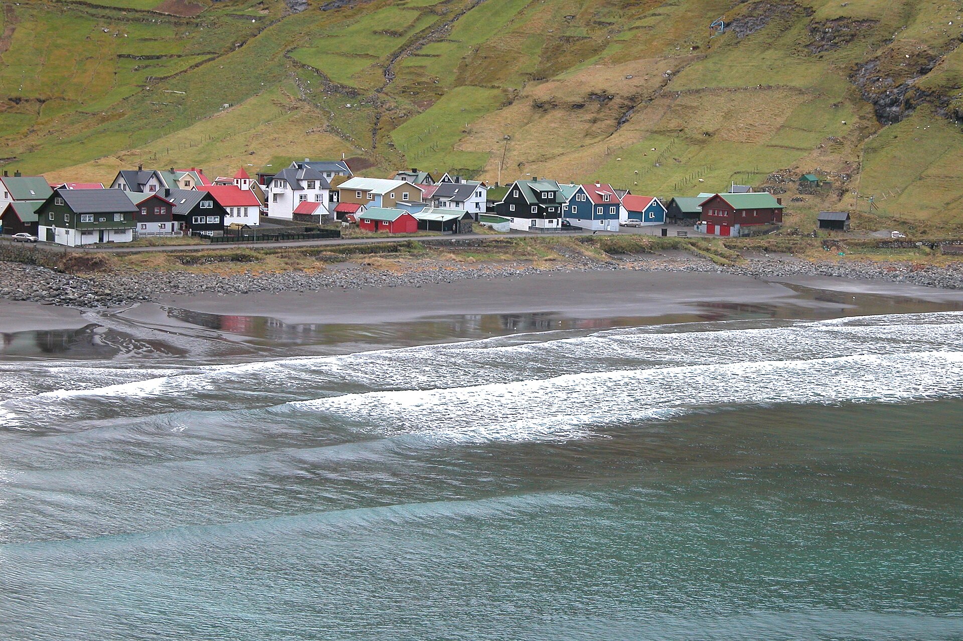
4. Saksun–Tjørnuvík village path
Snapshot
Itinerary
From Saksun, the village path begins above the church near Dúvugarðar and climbs diagonally up from the old infield. It reaches the ridge above Saksun, crosses towards Øksl and then follows a cairned path towards Tjørnuvíksskarð. From the pass, the descent leads northwards to Tjørnuvík, with views towards Eiði, Risin and Kellingin, and Slættaratindur. The Visit Vágar mirror of the official hiking entry gives 7 km, 2 h 25 min, medium difficulty, 522 m peak height and 529 m elevation.
Why it is essential
This is a classic Faroese village-to-village mountain path, linking two of Streymoy’s most distinctive settlements. It represents the historic overland routes that connected communities before modern roads and tunnels, while also giving strong coastal and high-pass scenery.
Equipment
- Sturdy boots
- Waterproof layer
- Warm layer
- Food
- Water
- Map/GPS
- Navigation backup
- Trekking poles recommended
Hazards and notes
- The initial climb from Saksun is steep and can be indistinct before the cairned section.
- Fog can make the pass and descent difficult to navigate.
- Wet grass and basalt stones can be slippery.
- One-way logistics require a car shuttle, taxi or verified public transport plan; otherwise the route becomes a longer out-and-back.
GPX / KML links
| Source | URL | Format | Notes |
|---|---|---|---|
| Official Visit Faroe / Visit Vágar hiking entry | visitvagar.fo | Official map / GPX source indicated | Official GPX source indicated, but direct file URL unresolved |
| Topo GPS user route | topo-gps.com | GPX download | Secondary GPS source; stats differ from official route |
| Wikiloc route | wikiloc.com | GPX source page | Secondary GPS source; route appears longer than official variant |
Sources
- Visit Vágar / Visit Faroe Islands — Saksun–Tjørnuvík
- Topo GPS — Saksun–Tjørnuvík
- Wikiloc — Saksun–Tjørnuvík
5. Hvannhagi and Hvannavatn from Tvøroyri
Snapshot
Itinerary
The official route starts and ends in Tvøroyri. From the hospital area, the way follows Ovari Vegur and then the marked path through the outfield towards Grindin. The path descends into Hvannhagi, a green valley holding Hvannavatn, with views towards Lítla Dímun, Stóra Dímun and Sandoy. The return can follow the approach line or pass through Frostgjógv, where loose stones and a short pathless section near a sheepfold require care.
Why it is essential
Hvannhagi gives the catalogue a Suðuroy walk and a different Faroese landscape type: enclosed green valley, Ice Age lake, geological rockfall scenery and island views rather than summit or headland terrain. Visit Faroe Islands describes it as a popular local and visitor hiking destination.
Equipment
- Sturdy waterproof boots
- Waterproof and windproof layer
- Warm layer
- Food
- Water
- Map/GPS
- Trekking poles recommended
- Navigation backup useful in fog
Hazards and notes
- Frostgjógv has loose rocks, especially risky for groups.
- After the sheepfold there is no visible path until the main Tvøroyri path is regained.
- Grass, stones and rocks form the main terrain.
- Fog can make route-finding harder.
GPX / KML links
| Source | URL | Format | Notes |
|---|---|---|---|
| Visit Faroe Islands official GPX | vfibackend.com | GPX | Official GPX found; reuse terms unresolved |
| Visit Faroe Islands route page | visitfaroeislands.com | Official route page and GPX link | Route and GPX verified as official source |
Sources
Region-level sources
| Source | URL |
|---|---|
| Visit Faroe Islands safe hiking guidance | visitfaroeislands.com |
| Visit Faroe Islands Slættaratindur | visitfaroeislands.com |
| Visit Faroe Islands Hvannhagi | visitfaroeislands.com |
| Trælanípan official visitor site | tralanipan.fo |
| Hiking.fo Kallur Lighthouse hiking fee | hiking.fo |
| Moonhoney Kallur Lighthouse route | moonhoneytravel.com |
| Outdooractive Slættaratindur | outdooractive.com |
| Visorando Sørvágsvatn / Trælanípan / Bøsdalafossur | visorando.com |
| Roadtripster Kallur Lighthouse | roadtripster.net |
| Roadtripster direct Kallur GPX | roadtripster.net |
| Visit Vágar / Visit Faroe Islands Saksun–Tjørnuvík | visitvagar.fo |
| Visit Faroe Islands direct Hvannhagi GPX | vfibackend.com |