Regional overview
Bosnia and Herzegovina contains some of the most rugged walking terrain in the Dinaric Alps: limestone ridges, karst plateaus, high shepherd settlements, glacial lakes, deep canyons, and forested national-park valleys. The main mountain hiking centres for this selection are Sutjeska National Park around Maglić, Prenj above Konjic and Jablanica, Čvrsnica and Blidinje Nature Park, Bjelašnica and the Rakitnica canyon, and Vranica above Fojnica.
The hiking character is generally wilder and less infrastructure-heavy than in the Alps. Many routes are marked, but trailheads often require private transport, rough-road access, or local logistical support. The Via Dinarica White Trail crosses Bosnia and Herzegovina over multiple high mountain groups and notes that sudden weather changes are common and that walkers should check current field conditions before departure.
The normal high-mountain walking season is late June to September, extending into October on some routes in stable weather. Snow can remain late on Čvrsnica, Maglić, Prenj, and Vranica; early-season snow or ice can make cable-protected, scree, and exposed sections much more serious.
Selection rationale
These five hikes were selected to represent the main hiking identities of the Bosnian Dinaric Alps: the national high point, a serious Prenj summit route, Čvrsnica’s famous natural arch, a Bjelašnica cultural-and-canyon landscape, and Vranica’s lake-and-ridge terrain.
Summary table
| # | Hike | Country | Route type | Distance | Gain | Max elevation | Difficulty |
|---|---|---|---|---|---|---|---|
| 1 | Maglić from Prijevor via Trnovačko Lake | Bosnia and Herzegovina / Montenegro border area | Loop / round trip | 12.6 km | 1,276 m | 2,386 m | Strenuous mountain hike |
| 2 | Crno Polje – Jezerce – Zelena Glava, Prenj | Bosnia and Herzegovina | Out-and-back | 20.6 km | 1,093 m | 2,072 m (route profile; summit-height discrepancy unresolved) | Hard / strenuous |
| 3 | Vitlenica – Hajdučka vrata, Čvrsnica | Bosnia and Herzegovina | Out-and-back | 16.4 km | 725 m | c. 2,000 m | Hard |
| 4 | Lukomir – Gradina Loop, Bjelašnica | Bosnia and Herzegovina | Loop | 13.8 km | 749 m | c. 1,884 m | Hard |
| 5 | Prokoško Lake – Nadkrstac / Vranica Ridge | Bosnia and Herzegovina | Loop | 16.9 km | 996 m | c. 2,102 m | Hard |
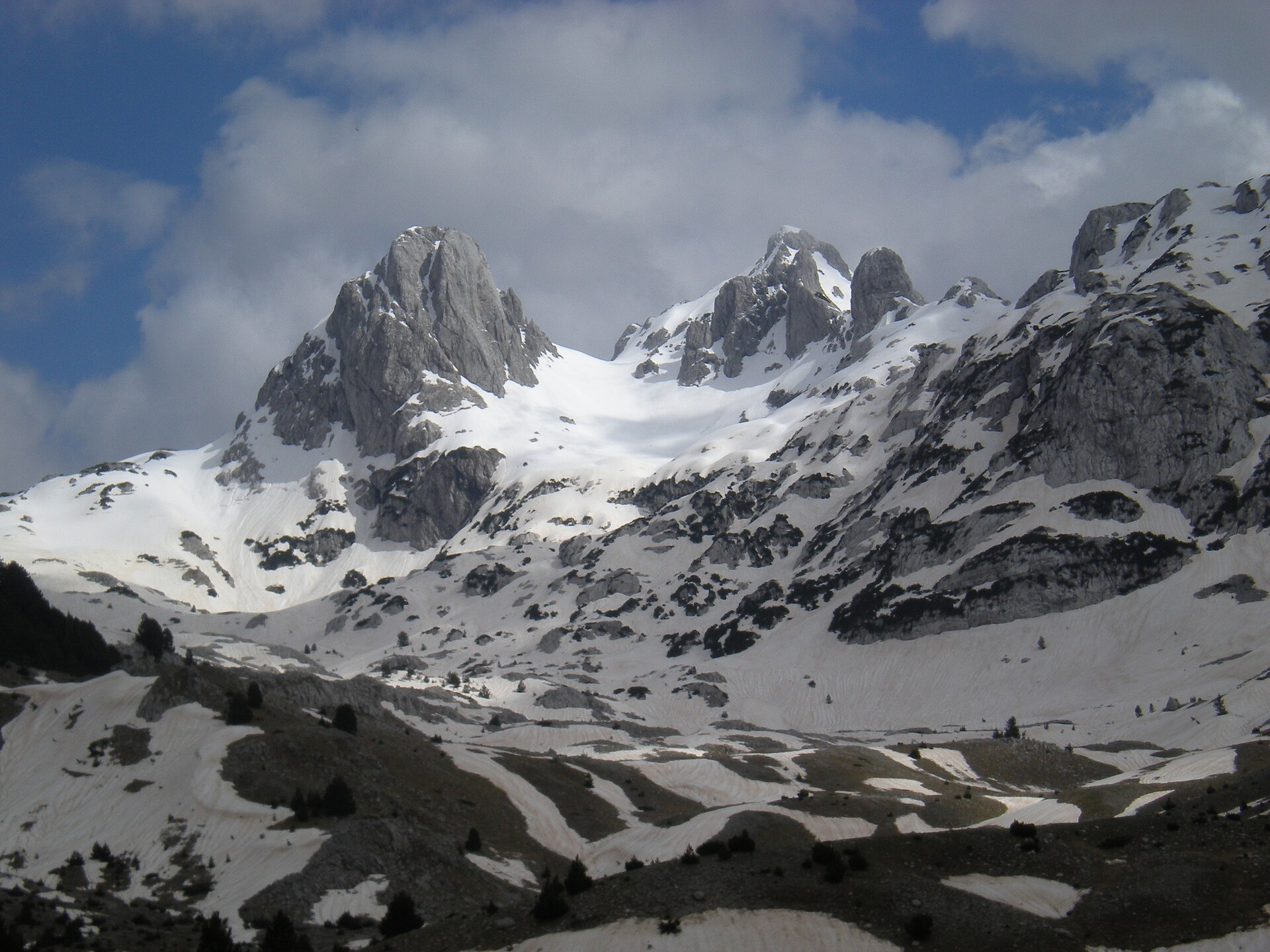
1. Maglić from Prijevor via Trnovačko Lake
Snapshot
Itinerary
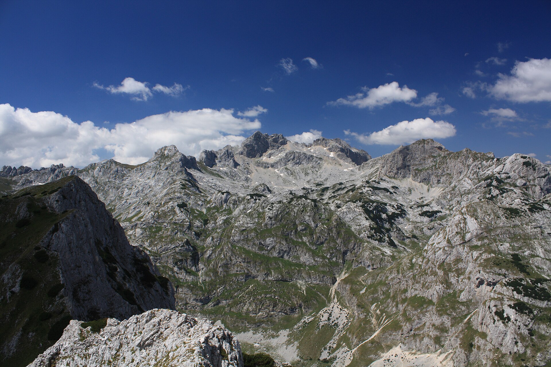
The route starts at Prijevor and climbs through forest before reaching steeper open ground below Maglić. The upper ascent involves scree, loose rock, exposed terrain, and a fixed cable section before the summit area. From Maglić, the route gives wide views over Sutjeska National Park, Volujak, Bioč, Zelengora, and Trnovačko Lake. The longer circuit continues towards Trnovačko Lake before returning to the Prijevor side. Via Dinarica lists this route at 12.6 km with 1,276 m ascent, 1,287 m descent, and a high point of 2,386 m.
Why it is essential
Maglić is the highest mountain in Bosnia and Herzegovina and the most iconic high-mountain objective in Sutjeska National Park. The route combines a national summit, a wild limestone massif, forest, scree, exposure, and views towards Trnovačko Lake.
Equipment
- Mountain hiking equipment
- Sturdy boots
- Weatherproof and warm layers
- Map/GPS
- Headtorch
- Water and food
- Helmet recommended because of loose rock and parties above
- A rope or local guide may be appropriate for inexperienced walkers on the cable-protected/exposed section
Hazards and notes
- Scree and loose rock
- Rockfall risk
- Exposed terrain
- Fixed cable section
- Not suitable for walkers with a fear of heights
- Thunderstorms and fog can make navigation and exposed ground significantly more serious
GPX / KML links
Route files will be replaced later with rebuilt GPX/KML files.
| Source | URL | Format | Notes |
|---|---|---|---|
| Via Dinarica route page | trail.viadinarica.com | Source map / route page | GPX/KML/FIT export controls visible on the route platform; direct file URL unresolved |
| Via Dinarica hiking page | viadinarica.com | Source route page | Use as route source until replacement GPX/KML is added |
Sources
2. Crno Polje – Jezerce – Zelena Glava, Prenj
Snapshot
Itinerary
The route starts at Crno Polje and follows forested terrain towards Picino Vrelo and the Jezerce area. It then continues over higher Prenj ground towards the saddle between Otiš and Zelena Glava. The final section to Zelena Glava includes steep mountain terrain and a steel-cable-protected section before returning by the same route. Via Dinarica lists the route at 20.6 km, 1,093 m ascent, 1,092 m descent, and 7 h 01 min.
Why it is essential
Prenj is one of Bosnia and Herzegovina’s classic limestone massifs, with a reputation for severe, high, rocky terrain. Zelena Glava and Otiš form one of the defining summit areas of the range, making this a key route for representing the more serious side of Bosnian Dinaric hiking.
Equipment
- Mountain hiking equipment
- Sturdy boots
- Trekking poles recommended
- Extra warm layer
- Navigation backup
- Headtorch
- Food and water
- Carry enough water despite springs on the lower approach, as availability can vary seasonally
Hazards and notes
- Physically demanding route
- Final ascent is steep
- Cable-protected section
- Road access to Crno Polje can be poor
- Passenger cars may not always reach the trailhead
- Stay on known marked routes in the wider Prenj area
GPX / KML links
Route files will be replaced later with rebuilt GPX/KML files.
| Source | URL | Format | Notes |
|---|---|---|---|
| Via Dinarica route page | trail.viadinarica.com | Source map / route page | GPX/KML/FIT export controls visible on the route platform; direct file URL unresolved |
| Via Dinarica hiking page | viadinarica.com | Source route page | Use as route source until replacement GPX/KML is added |
Sources
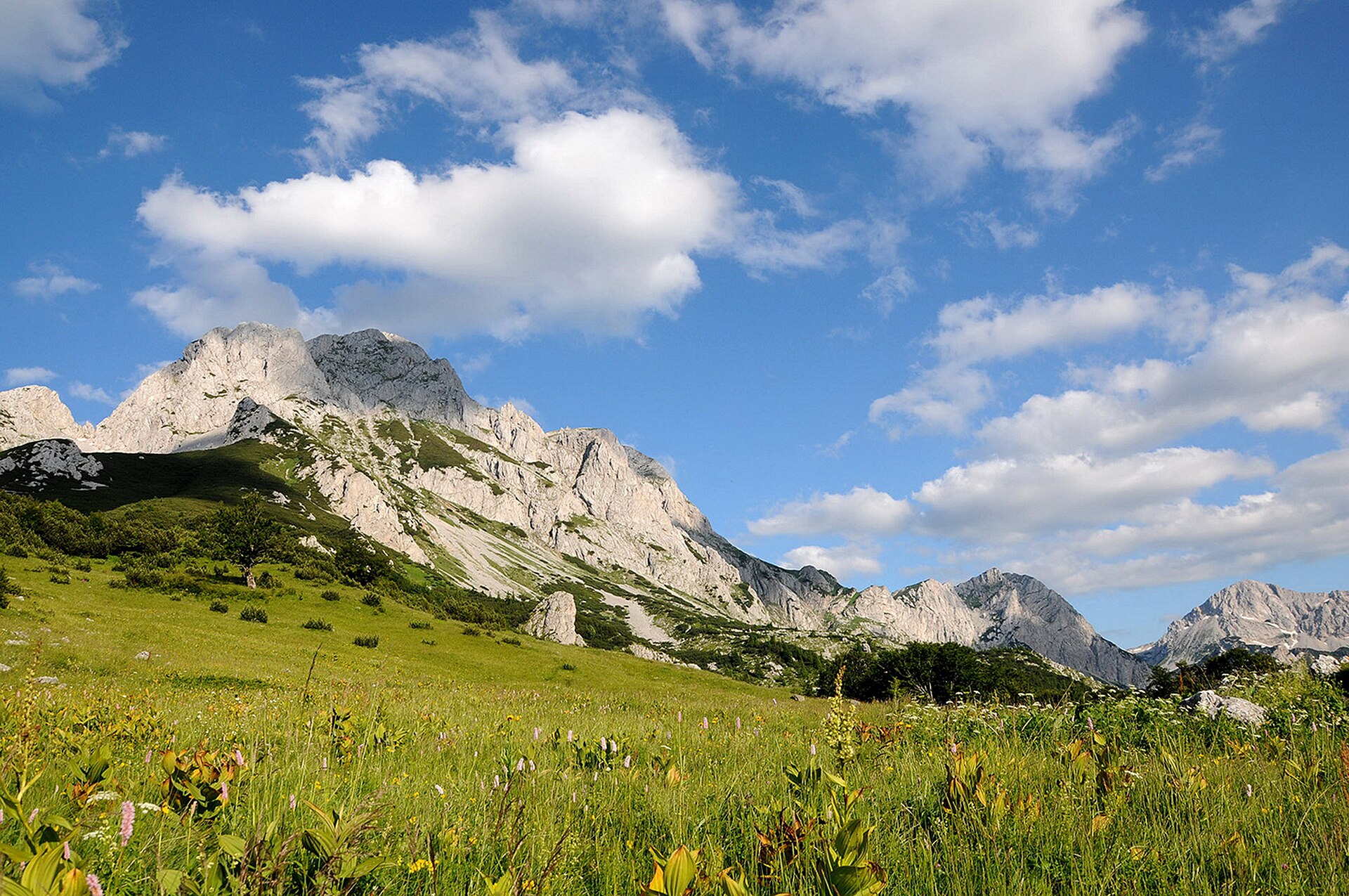
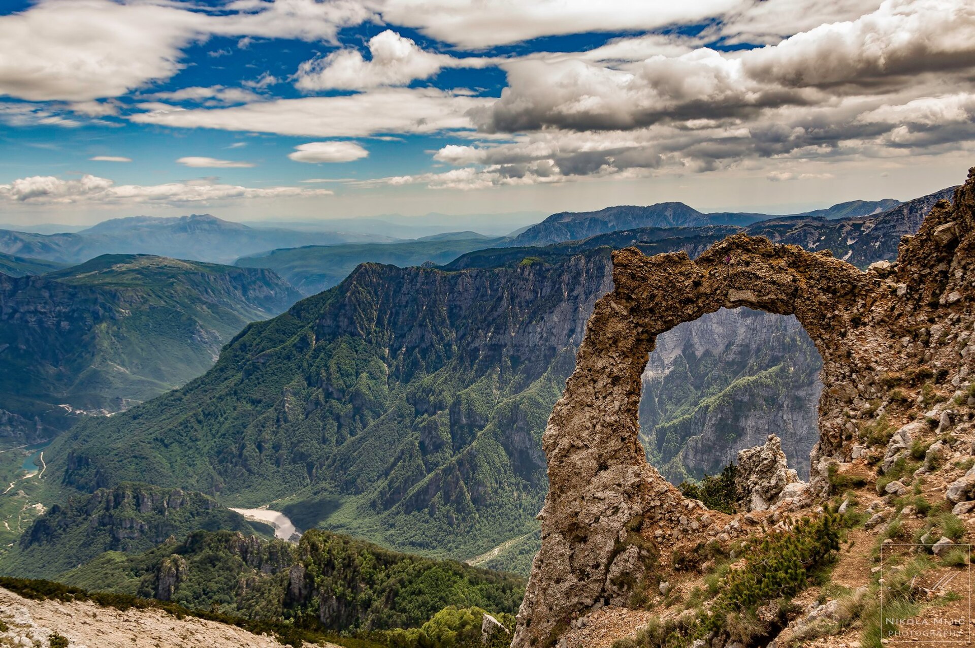
3. Vitlenica – Hajdučka vrata, Čvrsnica
Snapshot
Itinerary
The route leaves Vitlenica and climbs through forest and open high-karst terrain towards Hajdučka vrata, the natural stone arch on Čvrsnica. The walk is an out-and-back route, with the same descent back to Vitlenica. AllTrails lists the Vitlenica–Hajdučka vrata route as 16.4 km, 725 m ascent, hard, and out-and-back in Blidinje Nature Park.
Why it is essential
Hajdučka vrata is one of the most recognisable natural landmarks in the Bosnian Dinaric Alps. The route represents Čvrsnica’s high karst, open limestone terrain, and Blidinje’s exposed mountain character.
Equipment
- Mountain hiking equipment
- Sturdy boots
- Trekking poles recommended
- Warm and waterproof layers
- Map/GPS with offline route
- Food and sufficient water
- Microspikes may be required in early or late season if snow or ice remains
Hazards and notes
- Rocky terrain
- Uneven ground
- Possible scrambling
- Ice in spring conditions
- Offline navigation recommended
- Care required around the arch and nearby holes or drops in the limestone
GPX / KML links
Route files will be replaced later with rebuilt GPX/KML files.
| Source | URL | Format | Notes |
|---|---|---|---|
| AllTrails route page | alltrails.com | Source map | Direct GPX/KML export URL unresolved; use as route source until replacement GPX/KML is added |
Sources
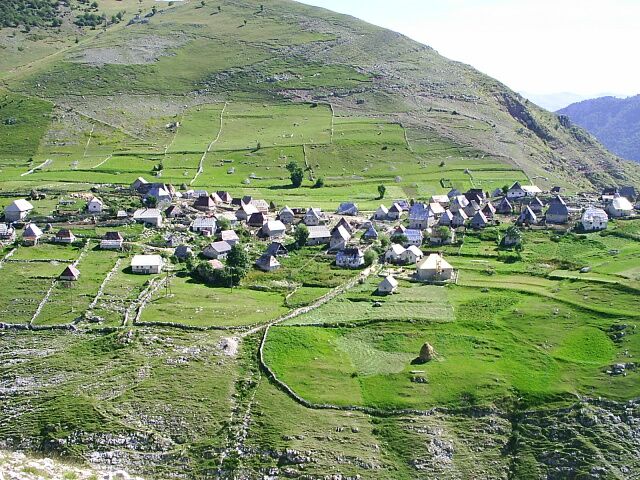
4. Lukomir – Gradina Loop, Bjelašnica
Snapshot
Itinerary
The loop starts in Lukomir, a high mountain village on Bjelašnica, and follows open upland terrain towards Gradina and viewpoints above the Rakitnica canyon. The route combines village-edge paths, pastureland, rocky grassland, and canyon-side views before returning to Lukomir. AllTrails lists the Lukomir–Gradina Loop as 13.8 km, 749 m ascent, hard, and a loop route, with river, view, and historic-site features.
Why it is essential
This is the cultural-landscape selection for the region. It links Bjelašnica’s high plateau, traditional settlement, and the Rakitnica canyon edge, giving a different character from the summit-centred routes on Maglić, Prenj, and Čvrsnica.
Equipment
- Standard to mountain hiking equipment
- Sturdy footwear
- Weatherproof layer
- Warm layer
- Water
- Food
- Map/GPS
- Sun protection
- Trekking poles useful on steeper or eroded sections
Hazards and notes
- Open plateau terrain is exposed to rapid weather changes
- Navigation can be difficult in fog
- Dogs are reported around village and pasture sections
- Snow and road access can affect the route outside summer
GPX / KML links
Route files will be replaced later with rebuilt GPX/KML files.
| Source | URL | Format | Notes |
|---|---|---|---|
| AllTrails route page | alltrails.com | Source map | Direct GPX/KML export URL unresolved; use as route source until replacement GPX/KML is added |
Sources
5. Prokoško Lake – Nadkrstac / Vranica Ridge
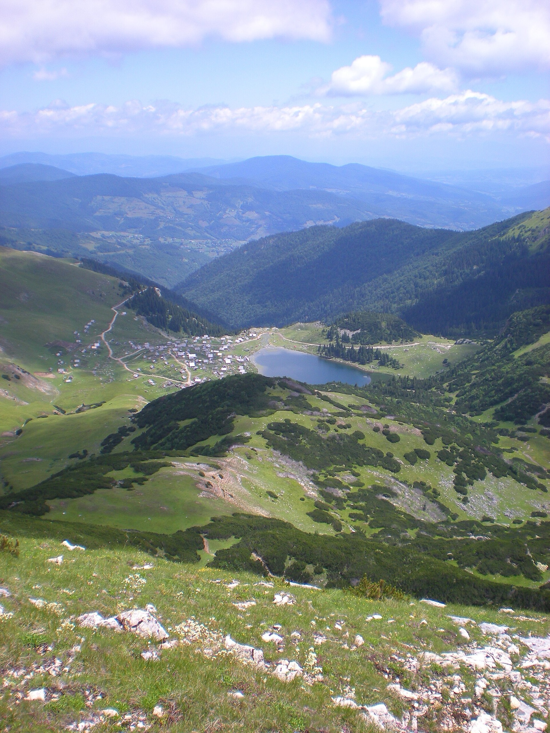
Snapshot
Itinerary
The loop starts at Prokoško Lake and climbs from the lake basin towards the Vranica main ridge and the Nadkrstac area. It then follows high open ridge terrain before descending back towards the lake and its surrounding huts. AllTrails lists the Prokoško jezero i Nadkrstac route as 16.9 km, 996 m ascent, hard, and a loop, with lake, forest, waterfall, views, wildflower, and wildlife features.
Why it is essential
Vranica gives the catalogue a gentler but still substantial high-mountain contrast to the limestone massifs farther south. Prokoško Lake, the shepherd-hut landscape, and the broad ridge to Nadkrstac make this one of the most representative lake-and-ridge routes in central Bosnia.
Equipment
- Mountain hiking equipment
- Sturdy boots
- Warm and waterproof layers
- Sun protection
- Water
- Food
- Map/GPS
- Navigation backup
- Trekking poles useful on grassy and eroded slopes
Hazards and notes
- Open Vranica ridge is exposed to weather
- Fog can make navigation difficult
- Snow can remain into early summer
- Road from Fojnica to Prokoško Lake is rough and unpaved
- Avoid damaging shoreline and hut-area habitats around the lake
GPX / KML links
Route files will be replaced later with rebuilt GPX/KML files.
| Source | URL | Format | Notes |
|---|---|---|---|
| AllTrails route page | alltrails.com | Source map | Direct GPX/KML export URL unresolved; use as route source until replacement GPX/KML is added |
Sources
External links
| Source | URL |
|---|---|
| Via Dinarica White Trail in Bosnia and Herzegovina | trail.viadinarica.com |
| Via Dinarica, Maglić from Prijevor to Trnovačko Lake | trail.viadinarica.com |
| Via Dinarica, Crno Polje, Jezerce, Zelena Glava | trail.viadinarica.com |
| AllTrails, Vitlenica – Hajdučka vrata | alltrails.com |
| AllTrails, Lukomir – Gradina Loop | alltrails.com |
| AllTrails, Prokoško jezero i Nadkrstac | alltrails.com |