Regional overview
The south-western end of the Alps links the high crystalline Mercantour and Argentera massifs with the limestone and karst landscapes of the Ligurian Alps. The region spans France and Italy, with major walking centres around Allos, the Tinée, the Roya and Bévéra valleys, Valdieri, Valle Gesso, Valle Pesio and Chiusa di Pesio.
The hiking character is varied: glacial lakes, larch forests, military mule tracks, granite basins, high alpine cols, pastoral plateaux and limestone amphitheatres. Several routes lie inside protected areas, especially Mercantour National Park, Parco Naturale Alpi Marittime and Parco Naturale del Marguareis. The Vallée des Merveilles adds a major cultural dimension through its prehistoric rock engravings.
The normal hiking season is late June to October, with July to September the most reliable period for high routes. Early summer snowfields can remain on cols, north-facing slopes and shaded high basins. Afternoon storms, sudden temperature changes and navigation issues in fog are recurring hazards.
Access is often by mountain road, with some seasonal shuttles and railway or bus connections in the Roya, Val d’Allos and Valle Pesio areas. Parking can be regulated or paid at popular trailheads such as Parking du Laus and Pian delle Gorre.
Selection rationale
These five hikes were selected to represent the region’s main hiking identities: a Mercantour landmark lake, a prehistoric high-valley route, a classic high-lake circuit in the Tinée, a Maritime Alps lake-and-military-road circuit, and a Ligurian Alps limestone-and-botanical loop.
Summary table
| # | Hike | Country | Route type | Distance | Gain | Max elevation | Difficulty |
|---|---|---|---|---|---|---|---|
| 1 | Lac d’Allos circuit | France | Loop | 7.6 km | +252 m | 2,264 m | Easy mountain walk |
| 2 | Vallée des Merveilles from Lac des Mesches | France | Out-and-back with optional discovery circuit | c. 14.5–16.0 km | c. +770–810 m | c. 2,130 m at refuge | Mountain hiking, long but non-technical |
| 3 | Circuit de Tortisse / Lacs de Vens | France | Loop | c. 14 km | +950 m | 2,591 m | Sportive mountain hike |
| 4 | Giro dei Laghi di Fremamorta | Italy | Loop | c. 15 km | c. +800 m | c. 2,380–2,450 m | E — Escursionistico |
| 5 | Laghetto del Marguareis – Rifugio Garelli loop | Italy | Loop | 11.872 km | +966 m | 1,966 m | E |
Note on route files. Route links are source references and may be replaced with project-owned GPX/KML files later.
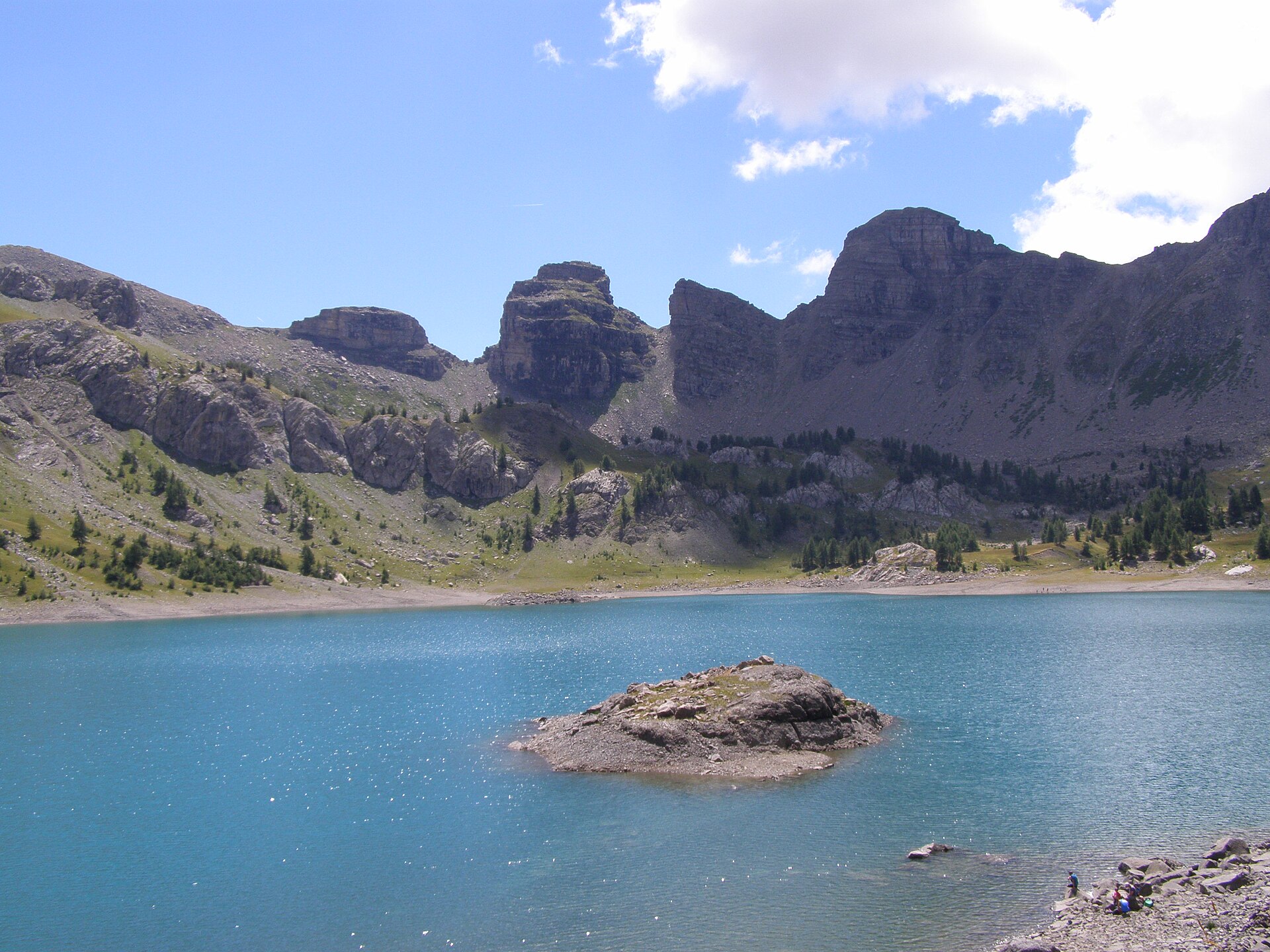
1. Lac d’Allos circuit
Snapshot
Itinerary
From Parking du Laus, the route climbs by stone steps, then follows the GR-marked track through larch forest towards the Lac d’Allos basin. The path reaches the lake near the chapel and refuge, then completes a circuit around the shore before returning by the outward route. The official route page describes the hike as a 7.6 km loop with +252 m and -250 m of elevation change, taking about 3 hours.
Why it is essential
Lac d’Allos is one of the defining landmarks of Mercantour National Park: a high glacial lake below Mont Pelat, accessible by a relatively short mountain walk. It provides a gentle but highly representative introduction to the park’s larch woods, alpine meadows, marmot and chamois habitat, and high-lake scenery.
Equipment
- Hiking shoes or boots
- Weatherproof layer
- Warm layer
- Water
- Food
- Map or GPS
- Sun protection
- Early or late season traction if snow remains
Hazards and notes
The access road to Parking du Laus is a small mountain road, normally open from mid-June to mid-October subject to conditions. In high summer, access is regulated, limited and paid between 07:00 and 17:00, with online reservation possible for some parking spaces. The route is inside the core of Mercantour National Park, so park regulations apply. The alternative start from the summer parking at La Cluite adds about 1 h 30 of walking.
GPX / KML links
| Source | URL | Format | Notes |
|---|---|---|---|
| Rando parcs Marittime Mercantour — Lac d’Allos GPX | marittimemercantour.eu | GPX | Official download. |
| Rando parcs Marittime Mercantour — official route page | marittimemercantour.eu | Source page | Official route reference. |
External links
2. Vallée des Merveilles from Lac des Mesches
Snapshot
Itinerary
The classic approach starts at Lac des Mesches and follows the restored pedestrian access route towards La Minière and the Vallon de l’Enfer. The path climbs steadily to Refuge des Merveilles beside Lac Long, at about 2,130 m. From the refuge area, marked authorised paths give access to a selection of engraved rocks and interpretive viewpoints; leaving these paths is prohibited. FFCAM lists the Lac des Mesches access route as 7.27 km one way, +771 m and -50 m, with a walking time of 4 h to the refuge. A full day-hike return therefore gives about 14.5 km and roughly 770–810 m of ascent, before any additional authorised engraving circuit.
Why it is essential
The Vallée des Merveilles is one of the major cultural landscapes of the Alps. The area contains nearly 40,000 open-air prehistoric rock engravings over about 15 km² around Mont Bégo.
Equipment
- Sturdy boots
- Warm layer
- Waterproof jacket
- Sun protection
- Food
- At least 1 litre of water
- Navigation backup
- Trekking poles with rubber tips
Hazards and notes
The engraving zone has special protection rules. Free circulation is allowed only on the GR52 and authorised connecting paths. It is forbidden to leave the marked route, walk on engravings, touch them, or use metal-tipped poles in the protected zone. Guided visits are available in season, generally from 15 June to 30 September. The protected engraving area is inside Mercantour National Park, and bivouac is restricted to delimited areas near refuges.
GPX / KML links
| Source | URL | Format | Notes |
|---|---|---|---|
| Refuge des Merveilles / FFCAM — Mesches access GPX | refugedesmerveilles.ffcam.fr | GPX | Official Mesches access route. |
| Refuge des Merveilles / FFCAM — Tende to Mesches variant GPX | refugedesmerveilles.ffcam.fr | GPX | Variant approach. |
| Refuge des Merveilles / FFCAM — Granile to Mesches variant GPX | refugedesmerveilles.ffcam.fr | GPX | Variant approach. |
| Refuge des Merveilles / FFCAM — Access routes page | refugedesmerveilles.ffcam.fr | Source page | Access route reference. |
External links
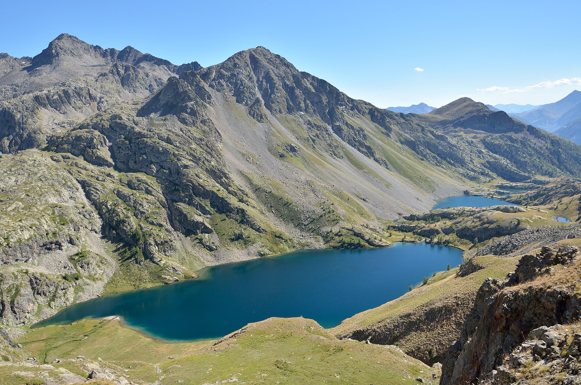
3. Circuit de Tortisse / Lacs de Vens
Snapshot
Itinerary
From Le Pra, the route climbs above the road to the plateau of Morgon, then crosses towards the forest houses of Tortisse. It continues to the Col du Fer at 2,584 m and the Collet de Tortisse at 2,591 m, beneath the jagged Aiguilles de Tortisse. The descent opens a sudden view over the chain of the Lacs de Vens and the CAF refuge at 2,380 m. The return traverses above the lake outlet, reaches a balcony collet at 2,422 m, and rejoins the outward route near the Tortisse forest houses.
Why it is essential
This is one of the best single-day routes for experiencing the high lake basins of the Haute Tinée. It combines historic forestry paths, the Aiguilles de Tortisse, views towards the Italian Val Stura and Monte Viso, and the glacial chain of the Lacs de Vens. The route lies entirely in the core of Mercantour National Park.
Equipment
- Sturdy boots
- Trekking poles recommended
- Warm layer
- Waterproof layer
- Food
- Water
- Map or GPS
- Sun protection
- Headtorch for a long day
- Microspikes may be useful in early season if snow remains
Hazards and notes
This is a long high-mountain loop with nearly 1,000 m of ascent. Snowfields can persist near the high cols and lake basin. Weather changes can make navigation more serious. Stopping and parking are forbidden beside the RM2205 at Le Pra; a parking area is indicated about 2 km downstream near the water track leading to the Torrent de Vens.
GPX / KML links
| Source | URL | Format | Notes |
|---|---|---|---|
| VisuGPX — Circuit de Tortisse GPX | visugpx.com | GPX | Secondary GPX source. |
| VisuGPX — route page | visugpx.com | Source page | Secondary route reference. |
| Randoxygène — official route page | randoxygene.departement06.fr | Source page | Official route reference; no GPX on page. |
External links
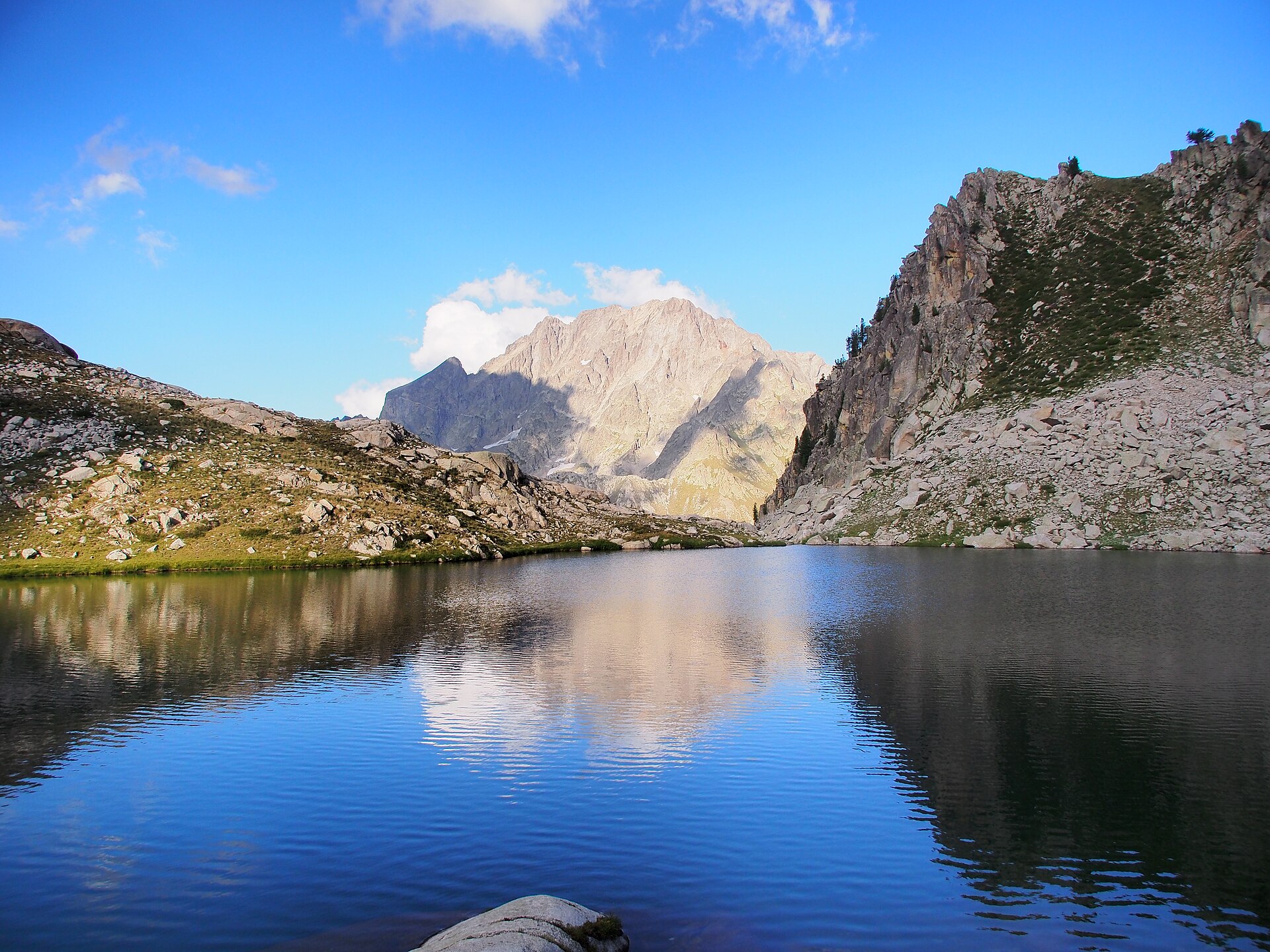
4. Giro dei Laghi di Fremamorta
Snapshot
Itinerary
From Gias delle Mosche, the route climbs into the Fremamorta lake basin and follows the former military road system past the lower and middle lakes. The circuit gives broad views across the Maritime Alps, including the Serra dell’Argentera and Corno Stella, before descending back to the Gias delle Mosche area. The Aree Protette Alpi Marittime guided-hike listing gives about 15 km, about +800 m, 3 h for the ascent, E difficulty, an easy scree section, no exposure, and a loop route.
Why it is essential
The Laghi di Fremamorta are among the most characteristic high-lake landscapes of the Italian Maritime Alps. The route combines granite lake basins, views to the Argentera group, and historic military roads and ruined barracks connected with the twentieth-century border history of the area.
Equipment
- Comfortable boots with good soles
- Layered clothing
- Waterproof jacket
- Water
- Packed lunch
- Map or GPS
- Sun protection
Hazards and notes
The official listing states that the route includes some easy scree but is not exposed. Dogs are allowed in the park only on a lead for this event route. Bad weather may require route changes or cancellation.
GPX / KML links
| Source | URL | Format | Notes |
|---|---|---|---|
| Rando parcs Marittime Mercantour — GPX | marittimemercantour.eu | GPX | Official download. |
| Rando parcs Marittime Mercantour — route page | marittimemercantour.eu | Source page | Official route reference. |
| AlpiCuneesi — GPX | alpicuneesi.it | GPX | Secondary download. |
| AlpiCuneesi — route page | alpicuneesi.it | Source page | Secondary route reference. |
| VisitCuneese — GPX | visitcuneese.it | GPX | Secondary download. |
| VisitCuneese — route page | visitcuneese.it | Source page | Secondary route reference. |
External links
- Aree Protette Alpi Marittime — Giro dei Laghi di Fremamorta
- Rando parcs Marittime Mercantour — L’anello dei Laghi di Fremamorta
- AlpiCuneesi — L’anello dei Laghi di Fremamorta
- VisitCuneese — Fremamorta Lakes
5. Laghetto del Marguareis – Rifugio Garelli loop
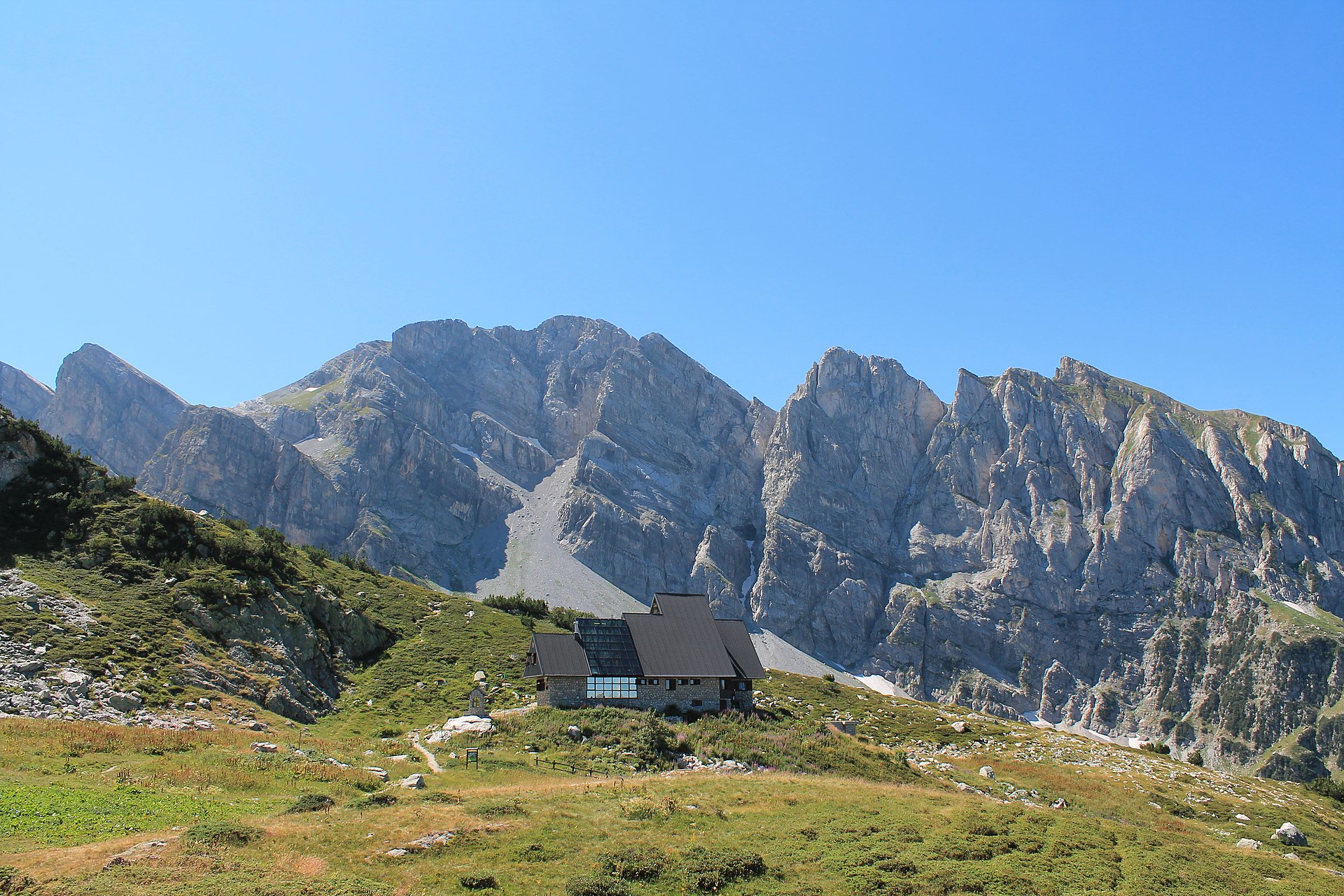
Snapshot
Itinerary
From Pian delle Gorre, the loop climbs to Rifugio Sestrera Sottano, then continues through beech and fir woods into the Vallone del Marguareis. The path rises through pasture and rocky ground to the Laghetto del Marguareis at 1,924 m, then traverses towards Rifugio Garelli at 1,966 m. The descent follows the Vallone di Sestrera back to Rifugio Sestrera Sottano and Pian delle Gorre. AlpiCuneesi describes the route as one of the most interesting itineraries in the park, moving from fir woods to the limestone walls of the Marguareis massif and the rounded pasture slopes of Gias Soprano di Sestrera.
Why it is essential
This route gives the most representative day-hike sample of the Ligurian Alps within this regional set. It combines limestone walls, karst-influenced terrain, fir and beech forests, alpine botanical stations, Rifugio Garelli and the Marguareis massif. It balances the granite lake basins of the Maritime Alps with the distinct limestone identity of the Ligurian Alps.
Equipment
- Sturdy hiking boots
- Weatherproof layer
- Warm layer
- Water
- Food
- Map or GPS
- Sun protection
- Trekking poles
- Early-season snow equipment if conditions require it
Hazards and notes
Early-season snow or wet limestone can make footing more serious. Information from route pages is not reliable in winter conditions with ice or snow; current route and weather conditions should be checked. Access is by road from Chiusa di Pesio through Valle Pesio to Pian delle Gorre. In summer, when parking fills, the road can be progressively closed from Pian delle Gorre down towards Certosa, and parking is paid.
GPX / KML links
| Source | URL | Format | Notes |
|---|---|---|---|
| Rando parcs Marittime Mercantour — GPX | marittimemercantour.eu | GPX | Official download. |
| Rando parcs Marittime Mercantour — route page | marittimemercantour.eu | Source page | Official route reference. |
| AlpiCuneesi — GPX | alpicuneesi.it | GPX | Secondary download. |
| AlpiCuneesi — route page | alpicuneesi.it | Source page | Secondary route reference. |
| Rando parcs Marittime Mercantour — Giro del Marguareis (related) | marittimemercantour.eu | GPX/KML source page | Related regional route. |
External links
- AlpiCuneesi — Pian delle Gorre / Laghetto del Marguareis / Rifugio Garelli
- Rando parcs Marittime Mercantour — La boucle du Refuge Garelli
- Rando parcs Marittime Mercantour — Giro del Marguareis
External links
| Source | URL |
|---|---|
| Rando parcs Marittime Mercantour — Lac d’Allos | marittimemercantour.eu |
| Randoxygène — Vallée des Merveilles | departement06.fr |
| Refuge des Merveilles / FFCAM — Access routes | ffcam.fr |
| Randoxygène — Circuit de Tortisse | departement06.fr |
| VisuGPX — Circuit de Tortisse / Lacs de Vens | visugpx.com |
| Aree Protette Alpi Marittime — Giro dei Laghi di Fremamorta | areeprotettealpimarittime.it |
| Rando parcs Marittime Mercantour — L’anello dei Laghi di Fremamorta | marittimemercantour.eu |
| AlpiCuneesi — L’anello dei Laghi di Fremamorta | alpicuneesi.it |
| VisitCuneese — Fremamorta Lakes | visitcuneese.it |
| AlpiCuneesi — Pian delle Gorre / Laghetto del Marguareis / Rifugio Garelli | alpicuneesi.it |
| Rando parcs Marittime Mercantour — La boucle du Refuge Garelli | marittimemercantour.eu |
| Rando parcs Marittime Mercantour — Giro del Marguareis | marittimemercantour.eu |